De excursión
Las mejores rutas de senderismo cerca de Seattle
El otoño es una de las mejores épocas para hacer senderismo en el noroeste.
Los senderos de la región ofrecen un espectáculo, con un follaje otoñal brillante que complementa nuestros emblemáticos árboles de hoja perenne. Además, las temperaturas más frescas hacen que no pase calor durante la caminata.
Excursiones en Seattle y alrededores para principiantes:
Para disfrutar de un paseo perfecto a principios de otoño, dirígete al Alki Beach Park, una larga franja de playa que se extiende desde Alki Point hasta Duwamish Head (un punto de referencia con vistas a la bahía de Elliott). A lo largo de los 4 km de paseo, disfrutará de vistas panorámicas del estrecho de Puget, las montañas Olympic y el perfil urbano del centro de Seattle. Comience en Jack Block Park, rodee el cabo en Anchor Park y diríjase al faro de Alki Point.
Longitud: 2,5 millas
Distancia desde Seattle Southside: 14 millas
Sendero Coal Creek
Al este de Seattle Southside, Cougar Mountain Park ofrece más de 35 senderos bien cuidados que serpentean a través de bosques, humedales, acantilados y cuevas. Coal Creek Trail es una popular ruta de senderismo boscosa con artefactos históricos, cascadas y puentes de madera. Siga el sendero por un profundo barranco, pasando por antiguos pozos mineros, traviesas de ferrocarril y otros restos de la minería del carbón de finales del siglo XIX. No hay mucho desnivel, por lo que es una buena opción si no quiere esforzarse demasiado.
Longitud: 6 millas ida y vuelta
Distancia desde el sur de Seattle: 13,5 millas
Parque Grand Ridge
Grand Ridge Park cuenta con 11 kilómetros de senderos panorámicos que serpentean a través de bosques de cedro rojo occidental. Esta zona silvestre de 526 hectáreas se encuentra justo al norte de Issaquah y el lago Sammamish, y está abierta a excursionistas, ciclistas de montaña y jinetes. Uno de los puntos destacados del sendero es un hermoso puente de 12 metros de largo, construido a mano, que cruza Canyon Creek.
Longitud: 14 millas
Elevación: 1.100 pies
Distancia desde la zona sur de Seattle: 25 millas
Caminatas con vistas cerca de Seattle
Sendero Granite Mountain
El sendero Granite Mountain Trail es la ruta de cima más transitada del corredor Snoqualmie Pass. Aunque es un poco agotador para las pantorrillas, las vistas de 360 grados del monte Rainier y Snoqualmie Pass hacen que la subida de 3800 pies en 4,3 millas merezca la pena.
Longitud: 8 millas
Elevación: 3.800 pies
Distancia desde el sur de Seattle: 52 millas
Sendero del lago Pratt
El lago Pratt, cerca del paso Snoqualmie, es ideal para esta estación de transición, y el sendero Pratt Lake Trail es perfecto para practicar pesca, escalada y otras rutas de senderismo. Se trata de una ruta de ida y vuelta de 13 km a través del bosque y alguna que otra pendiente rocosa, con vistas a las montañas, prados de flores silvestres y bosques antiguos.
Longitud: 8 millas
Altitud: 2.300 pies
Distancia desde el sur de Seattle: 52 millas
Cascadas Wallace
Situadas en la vertiente occidental de las montañas Cascade, las cataratas Wallace cuentan con una impresionante serie de nueve cascadas, la más alta de las cuales tiene una caída de 80 metros. La ruta de ida y vuelta tiene una longitud de 8,8 kilómetros y lleva a los aventureros a través de bosques de coníferas centenarios, junto a ríos de aguas rápidas, con vistas panorámicas de las montañas y una abundante fauna a lo largo del camino. Aunque las cataratas son hermosas durante todo el año, los lugareños recomiendan visitarlas en un día lluvioso, ya que cada gota de lluvia alimenta el río Wallace, amplificando la fuerza y el dramatismo de las cascadas.
Longitud: 5,5 millas
Elevación: 1.200 pies
Distancia desde la zona sur de Seattle: 55 millas
Monte Si
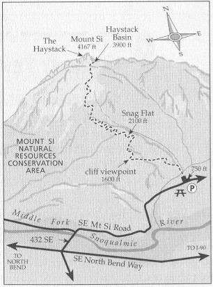
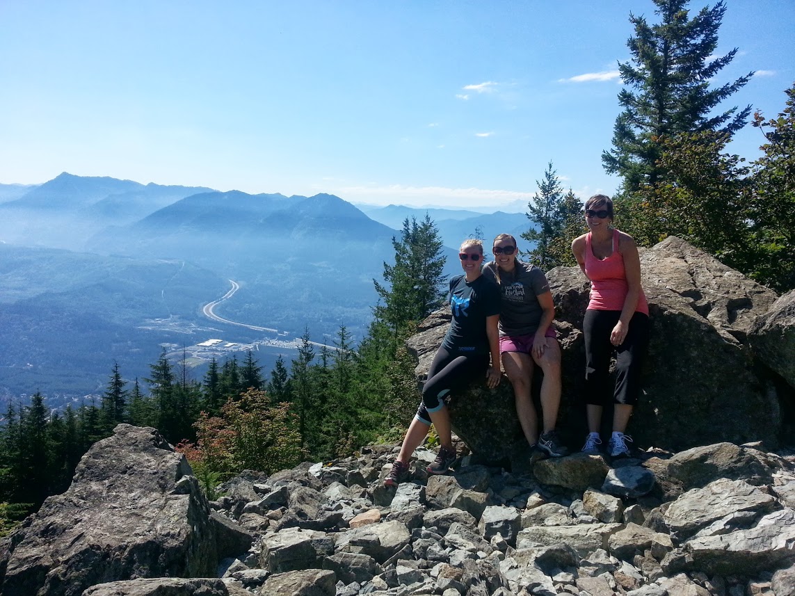
El monte Si es una ruta de senderismo exigente y muy popular situada en el Área de Conservación de Recursos Naturales del Monte Si, cerca de North Bend, en el estado de Washington. El sendero tiene una longitud aproximada de 13 km ida y vuelta, con un desnivel de unos 960 metros. La ruta comienza en un denso bosque de coníferas y asciende de forma constante a través de zigzags bien mantenidos. A unos 5,6 km, los excursionistas son recompensados con unas vistas panorámicas desde una ladera rocosa, que incluyen vistas del monte Rainier en días despejados. La última sección llega a una meseta situada debajo de la cima; los excursionistas experimentados pueden subir al «Haystack» para disfrutar de unas vistas panorámicas.
Desnivel positivo: 960 m
Distancia desde el sur de Seattle: 64 km
Para los aventureros, el Haystack del monte Si es una corta escalada hasta la cima y se considera un ascenso moderado de clase 2/3.
Nos sentamos bajo el sol y nos relajamos un rato, disfrutando de las amplias vistas, la fauna y algunos aperitivos. Después de posar para unas cuantas fotos y documentar nuestro logro, bajamos la montaña animando a los excursionistas que se dirigían a la cima.
Como se nos había abierto el apetito en la subida, nos detuvimos en el North Bend Bar and Grill para comer hamburguesas. Se trata de un restaurante de pueblo con buena comida y un ambiente acogedor. Incluso hay una chimenea con un enorme sofá para acurrucarse en los meses más fríos.
Longitud: 4 millas
Elevación: 3.700 pies
Distancia para Seattle Southside: 40 millas
Coge tus botas de montaña, agua y posiblemente un chubasquero, y sal al aire libre antes de que el sol desaparezca para el invierno.
También le puede interesar...

Dónde hacer ejercicio en la zona sur de Seattle
Correr, montar en bicicleta, saltar, estirarse... Hay infinitas formas de hacer ejercicio en Seattle Southside.

Ciclismo urbano: Lo mejor de la zona sur de Seattle
Pisa el pedal... ¡y pedalea! La bicicleta es una forma más ecológica y saludable de moverse por la ciudad.

Cuatro campings cerca de Seattle Southside
¿Quiere ir de camping cerca de Seattle?